
Wednesday, February 8, 2017
(February 8, 2017) A major, winter storm warning has been issued for several Northeastern states, with eight to 10 hours of heavy snow predicted along the eastern seaboard and the I-95 corridor. The overall greatest impact period from southwest to northeast is predicted to hit during the 3:00 a.m. to 8:00 p.m. period, with occasional thunder snow possible. Travel will be greatly restricted at times during the maximum snowfall period, as near blizzard conditions develop. 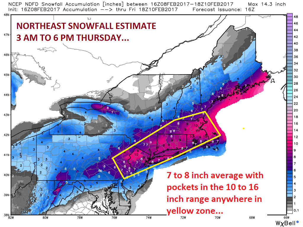
The storm begins with rain and sleet before turning into significant snowfall that is expected to disrupt morning rush hour in cities including Baltimore, Philadelphia, New York City, Boston, and other areas, with a full scale blizzard dropping up to one foot of snow in northeastern Pennsylvania and southern New York, as well as many other New England areas.
While the region’s average snowfall from eastern Pennsylvania and New Jersey across southeast to New York, Connecticut, Rhode Island, Vermont, New Hampshire, southern Maine, is predicted to be 7-8 inches, with 10-16 inches of snowfall possible.
Snow is predicted to move north and east from Pennsylvania and New Jersey during the 1:00 a.m. to 7:00 a.m. period into southeast New York and southern New England and then across portions of Vermont, New Hampshire, and Maine by mid-morning Thursday.
The snowfall rates will rapidly become heavy across most areas mentioned above and it is likely there will be a few periods of intense snowfall with high accumulation rates; possibly accompanied by lightning and thunder.
The snow will taper from southwest to northeast during early afternoon and evening hours winding down around noon across parts of eastern Penn. and New Jersey, during the early- to mid-afternoon hours across southeastern New York and much of Southern New England.
As for amounts, a regional average (all locations averaged into one number) of 7 or 8 inches is likely, but the potential for a couple of intense meso-bands and some convective snows means there will likely be zones of 10 to 16 inches. There have been hints that parts of eastern New York, northwest Conn., and southwest Massachusetts could stay under six inches but the highly dynamic nature of this storm could prove otherwise.
(Graphic courtesy: New England Propane Gas Association)
